
How is the urban planning of the City of Manila now?
The City of Manila is the capital city of the Philippines. Does it also lead as an urban planning model?
Here are 5 things you should know about the City of Manila’s urban planning.
More than 74,000 people live in each square kilometer of the City.
The City of Manila is at the top of lists of the densest cities in the world.
How many people are living in each square kilometer of the city? More than 74,000!
Per 2020 PSA data, the City of Manila has a population of around 1.85 million people in around 25 square kilometers of land area.
The concentration of population in the City of Manila is obvious in this population density map published by BA Racoma using 2015 population data.

The Comprehensive Land Use Plan of the City of Manila is not updated.
The status of the CLUP of the City of Manila is illustrates a central concern for Filipino urban planning: its land use plan is not updated!
Although the DHSUD lists the City of Manila as having “no CLUP,” an online slide deck of Asst. Prof. Sylvia Clemente shows the official zoning map of the City of Manila effective 2005 to 2020.
The UP Resilience Institute is working with the City Government of Manila in the PlanMNL2030 project, which aims to update the CLUP of the City.
Read: Formulating Comprehensive Land Use Plans in the Philippines
The Daniel Burnham Plan for Manila was not totally disregarded.
Filipino urban planners, architects and planning enthusiasts often bring up the Burnham Plan whenever traffic issues in the Philippines are discussed.
In short, the Plan was presented by Daniel Burnham, an American architect, to “create a unified city equal to the greatest of the Western World” out of Manila.
It was not completed, but not totally disregarded.
Dr. Nathaniel Einsiedel, in a 2020 lecture, enumerated the elements of the Burnham Plan that were implemented. These include the Luneta Park, the Jones Bridge, and the Manila City Hall.
I stand by my principle about the Burnham Plan: instead of asking “What if?” we should be asking, “What now?”

Manila needs real green spaces
Much has been written about how Metro Manila lacks open spaces and public parks.
To add to this problem, our existing public spaces are not as green as we would want.
A 2017 study found that urban green spaces in the City of Manila have more impervious materials (e.g., concrete pavements) than vegetation.
Only 19% of total urban green space area was vegetation, while 28% were impervious areas.
Add to this dangerous and incorrect rehabilitation of Manila Bay through the dolomite beach project.
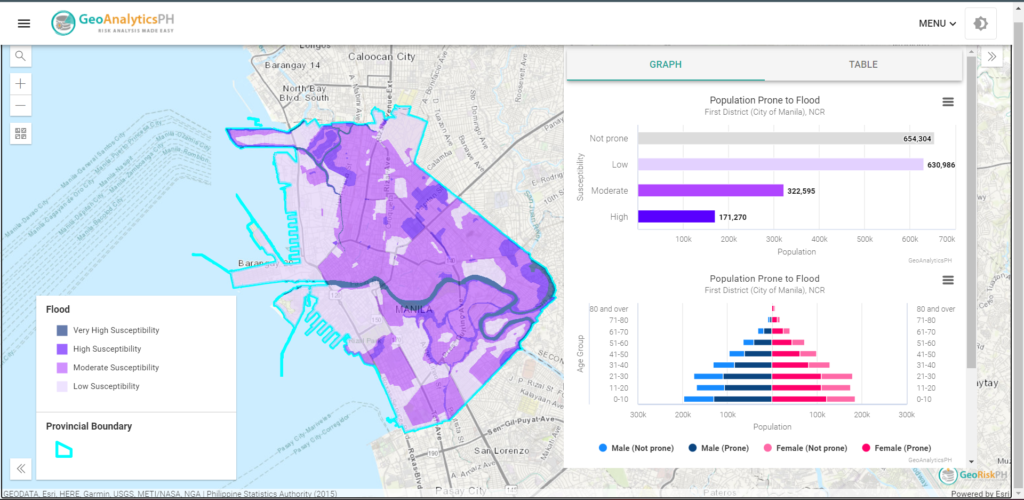
A tenth of the population of the City of Manila usually experience floods higher than 1 meter.
More than 170,000 residents of the City of Manila live in areas with high flood susceptibility.
MGB defines “high flood susceptibility” as being “affected by greater than 1m high flood. These areas are usually flooded for several hours during heavy rainfalls.”
The map generated through GeoAnalyticsPH shows the distribution of population according to flooding susceptibility.
Read: Top Websites for Planners in the Philippines
How can we solve a problem like Manila?
As the capital city, we must learn from the urban planning of the City of Manila.
Although experts have repeatedly described Manila as an urban planning mistake, I am hopeful that we can improve the Capital through sustainable land use planning.
What can you share about urban planning in your city?
Leave a comment or message me.